
208 miles in one Day
(Last updated: Thu. Sep 24, 2009)
Disclaimer
Though I'm a member of the Central Jersey Bike Club this page is not an official club web page. It is my personal page. Everything here is from my personal experience riding this double century. Also I'm not a doctor or athletic trainer so any advice here should be taken with caution. Check with professionals if you have any doubts. A double century done badly, at worst, will hurt you. Done properly it's an unbelievable accomplishment.
Looks like we'll have to share. Other Double Century folks will be
using this page as a reference to help them complete their
rides. So folks doing the first annual PFW
Garden State Double Century (GS Double), welcome! I hope you
enjoy the pages. Other than the description of the Longest Day
(
Update for 2010 and beyond
This page is being kept for historical reasons. Much of this material has been broken off into smaller pages to make it much easier to read and digest. Future updates may not be done to this page but will be done to the other pages. To visit the most currently maintianed page visit CJBC's The Longest Day
Update for 2009
![]()
CJBC presents:
The Longest Day
Saturday, June 13th 2009

It's that time of year again! :-) Yes, it's time to start training for the 2009 CJBC's Longest Day. This year Brian and Fran Sanchez will be running the event again (thanks!). It's a tough job that you can't really appreciate how hard it is until you've done it (yes Fran, maybe next year :-). And as usual, cabin fever set in and I added more to the page. Maybe this year I'll get a better photo gallery of the areas you'll visit. It might give everyone a better sense of the ride.
Updated for 2009
June 07, 2009 - Well that's pretty much it for training. Now it's time to clean and pack for the big ride next Saturday. I hope you have your planned stops, telephone numbers and anything else ready.
June 01, 2009 - with less than two weeks to go we have completed the review of the Longest Day route. The upper half pretty much remains the same but on the lower half there is a major route change in Tuckahoe. We'll try out this new method of getting to Rt 47 in Dennis. One nice feature of this route is that it gives us access to the rear entrance of the Woodbine WaWa (actually Dennis WaWa). Making it unnecessary to cross Rt 47 twice. Also there is major construction under the AC Expressway. This is of particular concern because the speed limit is 50. There is only one lane and if any one decides to move to the right of the traffic cones the high speed traffic exiting onto the AC Expressway may not notice them! This is going to be a major problem. I'll have to word this carefully.
May 25, 2009 - I hope everyone's training has gone well. For those who haven't yet ventured down to the Pine Barrens earlier this month they missed the green/yellow fog (wind blown pollen) and the strong headwinds. I don't expect either on the day of the ride. I do expect hot, humid and hazy. :-)
So far we've officially check from Amwell Rd in Millstone to the Lighthouse in Cape May (137 of 208 miles). Points of note are: the tar has risen on Canal Rd and I am concerned that if it's damp the roadway may be a little slick, there's a nasty sewer grate in Browns Mills that extends into the traffic lane that now has large holes around it, there appears to be some road construction in Tuckahoe on Rt 49 that will add about 0.2 miles to the route and I've been asked to make a few changes to reduce confusion. Nothing major but things that must be dealt with accordingly. I'll make these changes soon and I hope to have the changes in the new online Bikely routes. We'll have the northern section check out shortly and we'll make any changes as necessary.
Shortly I'll add two new sections, one pertains to where to find useful places for food, water, gas and restrooms. The other is a section on hand placement. One thing about long rides, if you keep your hands in one place through out the ride they'll be numb and painful before the end.
Updates for 2009 - Well this is starting to get huge! Okay, I've had that on this page since 2001. This page is everything I've pulled together since first doing the Longest Day ride. There's a lot information here but it's much to large to read in one siting. so I'm starting to work on new Longest Day page (yeah, right!). This page will still exist but I'll divide the information to many pages. This will make it easier to read.
Here's Sandy's Official CJBC 2008 Longest Day site. I'm keeping the link because I like the site. He did a good job on it.
So far I've updated this site by cleaning up the phrasing, spelling, and town names but expect more unfound minor errors. While I know every turn, crack and hole in the road I don't remember every road's name, sorry about that. This year I'll be leading training rides for the Longest Day starting in April. I intend to be ready early. Take a look at my bike blog as I'll be posting more information about the rides as the weeks go on. It looks like I've worked out a few new double metrics, centuries, and a lot more for training. I'll be testing them out come May. This year I'd like to see 18 mph avg riding speed. That may not be realistic speed to keep but I'll train for it anyway. I'm already doing rides to work. Remember you need to ride no faster than your slowest rider, anyway we'll see. Lastly I've added two of my posts from the newsgroup rec.bicycles.misc. They are reports on the Longest Day 2004 (our fastest yet) and the Longest Day 2005 (our worst though I should consider it a success, thanks Piers for pointing that out!). I may need to clean those up and add a few more facts.
The Longest Day
This site describes a bike ride held in NJ (USA) around the summer solstice. This date was chosen because it give the riders the maximum amount of sun light to complete this ride and it's one week before the start of the summer vacation season (price increase). It's a 208 mile, single day ride that starts in Port Jervis, NY and finishes in Cape May, NJ. Some people call it the High Point ride because it starts near the High Point monument. Officially the park is closed when most people start riding so we'd like to discourage you from going to the monument. It's held by the Central Jersey Bike Club (CJBC). To participate in this ride you must be a member of CJBC. You must also register and pay a fee for the ride. The fee pays for the effort to organize the ride. It also includes a shirt and a breakfast the following day. In the past the shirts have been very nice Polo shirts with wonderful embroidery over the left breast. In addition there was a medal given out commemorating the completion of the ride. It's worth the money as the club provides for meetings so people can meet to form teams, share information and also provide a checkpoint mid-way through the ride and at the end. This year (2008) Sandy has added a Longest Day Jersey ( see the front and back)
Remember a lot of this is either personal opinion or what works for me. I have completed 7 Longest Day rides, 2001 @ 15.8 mph to 2004 @ 17.8 mph. 2005 we had too many people (9) and we finished late (8:45 PM) @ 17.5. Here's my online planner (requires Javascript to be turned on). The white sections are where you change the numbers. Try changing the average speed and see what it does. Or change the stop times. It's not perfect and I probably need to add a few more things (if you have any suggestions just send me an email with the idea). It's really just tailored to my team but I thought it might be useful to others. Here are links to the 2009 cue sheet. I hope to have the unofficial alternate route to the High Point monument. I've laid it out and now I need to add the turns and street names.
2008 Routes
Don't use these, instead use the 2009 route below! We're in the process of making updates for various changes. This means that if you drop an old route into your GPS you won't make it to the lighthouse.
- CJBC's Longest Day Century (108 miles) - Starts in Allentown, NJ
- CJBC's Longest Day Double Metric (135 miles) - Starts in East Millstone/Hillsborough, NJ
- CJBC's Longest Day Double Century (208 miles) - Starts in Port Jervis, NY
- Longest Day Double Century directly to the hotel (208 miles) - This route will take you directly to the hotel (on Jefferson St, if that's where you're staying).
- CJBC's Longest Day Double Century w/High Point monument (212 miles) - Starts in Port Jervis, NY. This is not the official route and I've only included it for those who are interested. I've not tested this route so I won't vouch for it.
2009 Routes
If you download this to a GPS unit and you have the provided cue sheet, trust the cue sheet more than the GPS. This is because our first priority is to update the cue sheets. They are the official trip ticks. Also don't expect an exact mileage match when following directions. Mileage differs between computers, cars and the cue sheets. Numbers may be rounded in one place and added in another. The mileage will be close but not exact.
- CJBC's Longest Day Century (108 miles) - Starts in Allentown, NJ
- CJBC's Longest Day Double Metric (134 miles) - Starts in East Millstone/Hillsborough, NJ
- CJBC's Longest Day Double Century (207 miles) - Starts in Port Jervis, NY
In addition to the maps above you'll find the cue sheets (under the Show menu) which you can print out (we'll give you one that works with cue sheet holders the night before the ride), an elevation profile (also under the Show menu), and you can download the route for use in various GPS devices (under the Share menu). While these routes are kept up to date that doesn't preclude changes that may occur at the last moment. So I don't recommend those cue sheets as I may not have enough time to correct them before the Longest Day.
I've also added, for historic reasons, earlier route sheets from the 2001 (20th Anniversary ride) and 2002 Longest Day rides. No cue sheets will be provided for these rides as I prefer to dissuade you from trying those routes out. The route used on the 2005 (2003 through the present actually) is much safer. I also go on to describe my recollections of my first Longest Day (2001) which was a real eye opener and one of my favorite rides.
There are 3 different official routes, the double century (which I'll describe here), the double metric (which starts out outside of East Millstone, before Griggstown) and the century (which starts in Allentown, NJ). The double century ride is scenic but travels through some very busy sections of NJ (it's kind of hard to miss them). So dealing with traffic is part of the ride. Some of the other challenges are the hills at the beginning of the ride. They really aren't difficult (this from a a 'flatlander') but comprise the first 50 miles of the ride. Most of the 3463 ft. of climb and 3994 ft of descent are over by the first 100 miles. The rest is the flat lands of central and southern Jersey (NJ) where you never stop pedaling. Overall it's a down hill ride (500+ ft more descent than climb) from near the highest point in NJ (High Point) to the ocean at Cape May Light House. Some of the challenges are the hills in North Western NJ, the traffic of Northern NJ, the Pine Barrens (generally hot), the 'Doldrums' of the Pine Barrens in Lebanon and Wharton State Forests (doldrums A) and the 'Doldrums' below the May's Landing (doldrums B) and the final miles into the wind to Cape May. All these can be easily overcome by proper training. Training is an absolute must for a ride of this length. More on training below.
Planning
I've already done a number of these rides so I know what I do. I have my friend Mark Heck to thank for getting me started with my first Longest Day in 2001. I've since become some what of a mileage junkie though I don't record any of the mileage anymore. I'll be reworking this over time trying to improve the material.
I've created this Planning page (requires Javascript) so you can plan out your rest stops and what time you might expect to be at certain mile markers on the route. I actually use that page and the route map to figure rest stops and time.
The first thing you need to do is decide that you actually want to do this ride. I'll venture a guess that you've already decided that. :-) The numbers that follow are for planning and may not reflect what you'll actually experience on the ride. You should use your own numbers. For my ability these are a little low but they are quite doable.
- Review this cue sheet of the Longest Day Route. Make sure you have Javascript enabled. There's a link to the elevation and a cue sheet so you can get a pretty good idea of what you're getting yourself into.
- Figure out at what speed you want to average over the entire ride. Divide 208 by your avg speed and this will tell you the number of hours you'll be on the bike. Let's say your average speed is 15 mph over the entire 208 miles (some parts will be faster and some slower). That means you'll be on the bike for about 13.87 hours or 13' 53" (13 hours 53 minutes)
- Remember that you want to be at the Lighthouse before dark which is a about 8:15 PM. Subtract 13' 53" from 8:15 PM, that would be 6:22 AM. Now you have a base time for your start. That is to say that if you were to start at 6:22 AM, jump on the bike and ride non-stop for 13' 53", you'd then arrive at the Lighthouse at 8:15 PM if everything went perfectly. That doesn't sound like a fun ride so we need to add a few things to that time to make it more manageable.
- Figure out how many stops you want to make and for how long. If you make your stops every 20 miles or so then you'll have about 10 stops (the finish is the 11th stop and it's 8 miles past the 10th stop, something to think about). If you make each stop 15 minutes that's 150 minutes. As a precaution add a little padding and assume 2 - 15 minute stops for bike repairs, now that 180 minutes (3' or 3 hours). Subtract 3' from the 6:22 AM and you have 3:22 AM. Now you have a start time and an estimate of your stops.
- Now comes the hard part. Putting your team together. Look for folks who want to ride as a team (very important). A group that you'll be able to deal with over 208. Start training with them, as the date approaches try to ride with the team on long rides above your intended pace. Training rides are generally faster than your intended pace because they're shorter than your intended distance. Sometimes, on the Longest Day, you can meet up with other teams and ride together for a while but that's not a good way to plan out your ride. But it is a good way to take advantage of a good thing. Oh, and be courteous, ask if you can jump in with another group. They might not be comfortable with strangers.
- I've added general items below, after the description of the ride.
Training schedule
Hmm, I can't believe that I didn't have this here. Yet it's one of the most important thing you need to do to be able to do a double century. I'll work on this though I recommend that you take this with a grain of salt. I have never been able to use the training schedules presented by magazines like Bicycle. My life doesn't work in such nice neat time slots. Also the weather never cooperates. One thing I will tell you, there are at least three things you need to train for: some hills, some very flat sections and heat. The last one can be difficult to train for because the weather leading up to the Longest Day may not cooperate.
Here's a 10 week program, that means you need to start training in April. It's actually better to start in January but some folks may not decide until April to actually do the ride. If you're starting in May you've got some work cut out for you (watch out for stress injuries!).
| Week | Weekday totals | Saturday | Sunday | Comments |
|---|---|---|---|---|
| 1 | 30 | 40 | ||
| 2 | 30 | 40 | 15 | |
| 3 | 40 | 40 | 20 | |
| 4 | 40 | 60 | 20 | |
| 5 | 45 | 80 | 20 | |
| 6 | 45 | 100 | 20 | |
| 7 | 60 | 100 | 20 | |
| 8 | 60 | 100 | 40 | |
| 9 | 60 | 100 | 60 | at speed |
| 10 | 20 - 40 easy miles | 208 | Off | Ride week, take it easy |
I kind of hate putting these tables together as they don't reflect the reality of your training schedule. I ride during the week as family, work and weather allow and I also ride on the weekends. By the time I reach the end of May I'm riding double metrics (instead of centuries), which I feel better prepare me for the Longest Day. It's been said that you shouldn't increase you miles more than 10%/week. If I did that I'd have to start training in February. Technically I do but February is a brutal month to try and rack up miles. Also quite a few of my routes are a little tough to increase by small amounts. So I use a 15 - 20% rule. The numbers above are kind of low for me.
 The ride
I love this ride and, it's my favorite ride of the season. As I've said, I'm a bit of a mileage junkie. I need miles but I need to keep them to a single day. Otherwise I'd be doing brevets, like Boston-Montreal-Boston or Paris-Brest-Paris, both 1200 km. There's nothing like saying that you've completed a double century as part of your list of riding accomplishments. One important thing to note, this ride is not 200 miles it's 208 miles. Those extra 8 miles can really beat you up mentally if you're not expecting them.
Mike Kruimer (retired CJBC President) likes to say that the Longest Day is "All down hill". That means it's more down hill than up hill. My team should average about 17 mph for the entire ride. Since a few of us are poor climbers that means we're slower on the first half than on the last half. There are no real killer climbs on the ride. There are one or two surprises such as a short nasty climb outside Newton, a short up hill roller before the Ranger Station and the bridge over the canal in Cape May. There are long climbs and as long as you keep a steady pace you should do fine. The descents are fast and it's easy to hit speeds in the 40's (mph) without too much effort. There are a few locations where traffic becomes a concern.
 Oh 400 or Oh my God! How early?
We start out at 4 AM. It's usually cold, about 40 - 45F. It's also before sun rise so you'll need lights. Our SAG wagon follows us with the high beams on so we have a general view of what's around us. Bike lights are a must as they light up the road directly in front of you (the SAG can't). I also find that a cheap pair of safety glasses are a good idea as it keeps junk out of your eyes. Mine are either clear or amber. Amber really works well. We need to be on the look out for bears (really), deer, and skunks. The first section is a set of rollers which can be annoying as the road twists and turns so you'll loose the SAG wagon lighting your way from time to time. Once the sun is up you'll begin some of the climbs that are on this route. We tend to dump all our extra clothing and lights when we hit Newton (mile 26.8), our first stop. After this there are a few more climbs to come.
Just outside Andover, around mile 33, is an interesting feature, a tunnel! For the extremely childish among you, it should be noted that this tunnel makes an excellent echo chamber. ;-)
 Stanhope/Netcong Near Rt 80
The worst section of traffic is in Stanhope (mile 37.8), near Rt 80. You want to get here as early as possible and avoid the initial part of a Saturday morning rush hour. The reason is that you must cross 2 lanes of traffic to use the left exit ramp (from Rt 206 to Rt 183 into Netcong). We tend to get there before 7 AM and that seems to work well. We just catch the beginning of the rush hour. The next challenge is the climb out of Netcong. You have the Rt 46 circle (with underpasses) and then Rt 80. There seems to be a reasonable shoulder but the traffic is fast so it's not the most comfortable of places to ride. After you finish the climb there is the decent into Flanders . It's a great descent except for the traffic light mid-way (with a sewer grate where you'll be riding). The light is usually red (grrr!).
 Chester to Bridgewater
The next section is Rt 206 between Chester and Bedminster and at 8 AM in the morning it's rush hour so you will be sharing the road with cars. The shoulder is reasonable though the traffic speeds are fast. The nice thing about this section is that if you have a good team this is the first place to really pick up time. Its mostly a down hill ride (see the Hills diagram below, it's hill G). After climbing out of Flanders (the hill up to point G) the rollers start and they're great for pace lines. You can really get going here and pick up some of the time you might have lost on the climbs. In 2008 they paved the Rt 206/Rt 287 underpass. The sewer grates are still there but the pavement is so much nicer!
Between Rt. 287 and Foothill Rd the road isn't too bad. Once you're off Rt 206 in Bridgewater traffic drops off. It picks up again as you cross Rt 287 between Finderne and Manville. Watch the road condition as it's getting worse over the years. Again you'll be dealing with 'in town traffic' in Manville.
 Manville/Griggstown Canal/Kingston/Plainsboro
Outside Manville pace lines can begin again. Especially when you get to Canal Rd. The double metric starts somewhere around here. Just be careful as the roads are narrow and because it's a chip seal road iy may be a bit slick. Especially if the tar has risen. Anyway, welcome to the start of the flat lands. From here on to Cape May there are no long climbs (though there are a few surprise, short, steep climbs later). You'll pass through Millstone, Griggstown, Kingston, Plainsboro and West Windsor with light traffic. In Plainsboro you'll return to sharing the road with moderate traffic but the roads are a bit wider.
 Around mile 88 is the Grover's Mills that is mentioned
in H.G. Wells "War of the Worlds". Supposedly the barn building
on the left is the landing site and behind it (hidden) was the
shot up water tower. So far the winds have either been mostly West
or South West. The next 20+ mile section is a mostly west-east
ride towards Allentown which means that just before lunch a bit of
speed can be picked up as well as doing pace lines. Don't over do
it as you still have about 110 miles left after Allentown.
Around mile 88 is the Grover's Mills that is mentioned
in H.G. Wells "War of the Worlds". Supposedly the barn building
on the left is the landing site and behind it (hidden) was the
shot up water tower. So far the winds have either been mostly West
or South West. The next 20+ mile section is a mostly west-east
ride towards Allentown which means that just before lunch a bit of
speed can be picked up as well as doing pace lines. Don't over do
it as you still have about 110 miles left after Allentown.
 Allentown, Lunch!
Just before Allentown you'll cross the Rt. 195 overpass, welcome to south Jersey! The century ride starts around here. My team will arrive in Allentown around 10:30 AM, eat, clean up and prep the bikes for another hundred. We want to leave here relatively quickly as the next part of the ride begins the Pine Barrens and the heat. Of course we still need to have a few minutes off the bike as we've just completed a century (congratulations! Except for those who are doing the century and double metric, No soup for you! ;-) ).
BTW, the gentleman in the photo was in Cape May when the photo was taken. I just didn't have any good photos for Allentown. If you hover your mouse over the photos you should see my caption. I think every photo on the page has something.
 The Pine Barrens
Between Allentown and the Ranger Station is Ft. Dix Military Reserve, Browns Mills and Lebanon State Forest. In some sections the roadway is nicely shaded. There are many farms, the scenery is nice and the traffic low. There's one surprise rolling uphill just after the turn onto Upper Mill Rd (mile 123). Then you cross Rt. 70 to the Ranger Station. This is a good place to stop, hit the restrooms and wash up quick. Once past the Ranger Station (we usually arrive around 1 PM) there is no relief from the sun. The route turns south, the roadway is wide and long (13.8 + 5.4 or 19.4 miles) and there is little tree cover. While I love the heat most of the other folks I ride with can suffer pretty badly. BTW, those bleach bones along the side of the road are not deer, they're cyclists. :-) So I'd recommend adding a stop 22.2 miles (~2:30 PM) after the Ranger Station to give rest, fill up on fluids, grab some food and to get out of the sun. Try to find a shady spot to stop. In 2008 (hot and humid) at least 7 teams seemed to all meet up at the Rt 563/Pleasant Mills Rd stop sign in Green Bank. This is the end of the first part of the 'doldrums'. It's not usually too bad as you've probably just gotten off the earlier lunch break. If it's hot (90+F) this section will be brutal. Oh, you'll probably notice a change in direction in the wind. Get used to it you'll feel it the rest of the day.

After this stop we plan another stop 20 miles (~4 PM) further down the road, after the Atlantic City Expressway. This is still the heat of the day so take the appropriate care.
The next section, AC Express Way (mile 156) - May's Landing (mile 162) - Woodbine (mile 184) is again what I refer to as the second doldrums. It's where weariness sets in. You're physically tired, mentally tired and possibly emotionally drained. The scenery doesn't change and it's kind of bland (well after almost 160 miles it's kind of bland). This is where emotions can flair and mistakes can be made. Like overlapping the wheel of the rider in front of you. Instead of that excitement a shot of caffeine might not be a bad idea but back it up with some liquids and some carb's. Be careful here!

While on the topic of the NJ Pine Barrens let's add a word of caution. You already know to be wary of snapping turtles, bears, cougars, coyotes, pine flies, mosquitoes, ticks, snakes and the decaying remains of mob hits. Well the NJ Pine Barrens is also home to the Jersey Devil. To this day people swear that they've seen it (it was on the history channel recently, they never lie!). In 1909 the Devil went on a week long rampage where it was seen as far away as Philadelphia (I hear the zoo is quite nice). It was last seen in NJ in 2007. While little is know about the Jersey Devil what is known is that the Jersey Devil has taken a likening to cyclists. Seems that the chamois creme (Butt BUTT'r) is like steak sauce. So meddle not in the affairs of the Jersey Devil for you are crunchy and good with ketchup! ;-)
")
Dennis/Woodbine/Cape May Court House
Something about this section picks up the spirit and changes the mood of the ride. Probably it's the name, Cape May Court House, the other reason is that you're out of the 'Doldrums'. It might even be that you only have about 23 miles to go. This is a good place for a stop at a near by WaWa (they have bathrooms, drugs - like ibuprofen, and junk food what more can you want ;-). You still have about 25 miles to go and you'll probably experience a head wind. Ignore the head wind, do pace lines and don't push too fast. Be prepared for at least one more short, steep climb over the Cape May canal (who put that mountain here!) at mile 203!
One other thing I'd like to point out. As it is getting later in the day and graduation season is upon us, keep in mind that the traffic picks up here and that a number of the cars could contain high schools graduates (and all which that entails). Also don't be surprised at a number of people just honking to say hello. That's something that has always surprised me in this section, the number of people who honked and waved. Or it could be that I'm hallucinating. ;-)
200 Miles! (Rio Grande, NJ)
Surprise! No Lighthouse! Remember that the Lighthouse is at 208 miles not 200 miles. You still have a little bit of a distance to go (30 minutes at 16 mph avg speed). At around mile 203 you'll have the last mountain to climb. It's the bridge over the Cape May canal. After nearly 100 miles of no climbs this is quite a surprise. As I recall, from my first Longest Day: "Oh my god, who put that mountain there!". Don't worry you'll make it.

The Light House
Finally "The Lighthouse" is in sight but you still have 2.5 miles left to get there! So take it easy, keep your pace and you'll all make it in one piece. One important thing to note. When we've arrived at the lighthouse after 8 PM we've noticed a significant number of mosquitoes (even if it's windy!). But when we've arrived before 7:30 PM we haven't noticed the mosquitoes. Also stay away from the reeds. Away from the reeds the wind is stronger and the mosquitoes avoid a good breeze. Just food (which might be you) for thought when planning your ride!


You made it!
Well we did anyway, the photo left is the Team I was on in 2008. From left to right: Gina Lipman, Thos Cochrane, Sandy Somers, Mark Heck, and myself Neil Cherry. Really it's not as hard as one might think to do the Longest Day. It does require planning and training but once you've done it you'll be surprised that it wasn't as difficult as you expected. Obviously we weren't the only ones to make it as evidenced by the photo right.
Training recommendations
I have found that I can build up to a century from very little riding in about a month's time (I've been riding centuries for a long time). At that point I'll actually be riding centuries. I've found that to train for a double century is an entirely different matter. It will take me an addition month and a half to get my training up to par. What I tend to do is to build up to a century at a speed greater than I intend to ride the double at. I follow that up by building up to a metric (62.4 miles) ride the day after the century. The metric must be completed at least at the intended pace of the double century. This gives me a total of 160 miles over 2 days. This year I added a double metric instead of a century so as to make sure I had enough saddle time on my butt.
While training I found I needed to figure out what I can drink, what I can eat, how long I can hold off going to the bathroom, how to mentally handle the doldrums (you can experience the mental fatigue on early centuries around mile 70), clothing to wear, ride position, equipment choices, how well you handle the heat, direct sun, wind, etc. and how well you work with others on your team.
To help alleviate the mental exhaustion we found that playing mental word games, really bad puns and joking around works well for us. Also it allows you to gauge others more accurately. When some one is very quite they're very tired.
- Make sure your bikes are in good running order! There is nothing worse than a bike in need of repair. There are very few bike shops along the way so getting repairs done means stopping the ride. BTW, pre-1990 rims may not handle modern high pressure tires properly. They tend to blow off the rim when pumped up to the full pressure, every time. Once might be a pinch flat, twice maybe you're not putting the tire on correctly. Three times may be a bad rim.
- Don't make any major changes at least 2 weeks before the ride. Such as breaking in a new bike, position changes, new shoes, new shorts or diet changes. On my very first ride one of our riders added a new diet supplement a few days before the big ride. It caused diarrhea which in turn caused dehydration. By mile 120 the rider was really suffering. By mile 180 we thought he should finish the ride in the SAG wagon (ending his ride), He refused. Later we found out he doesn't even remember that conversation and he had 3 months of kidney problems after the ride.
- This leads up to my next suggestion: Drink before you're thirsty, early and often. If you're not getting enough fluids then drink twice as much when you do drink. Dehydration will sap your energy and make you tired for the next few days (or worse, see above). I've found that a Camelbak makes it very easy to get enough fluids. Some folks don't like riding with all that weight on their shoulders. I ride with a 3L bladder normally but I may switch to the 2L bladder for the Longest Day.
- Water is not enough! You're going to be sweating like mad and water won't replace the electrolytes you'll sweat out (even on a cold day). Figure out what you can drink. I can handle Lemon-Lime Gatorade but not Orange and not Cytomax. Just drinking soda is a bad idea, it can cause you to feel less thirsty. That doesn't mean you can't have soda at your stops.
- Eat small portions, often. Don't eat one big meal. Instead try eating more often but in smaller amounts. This way a load of food won't sit in your stomach like a ton of lead. One thing about a double century. You most likely won't be able to take enough calories to replace what you are burning up. At lunch only eat half your meal. Instead save the rest for a little later in the ride. Perhaps the next stop or one stop later.
- Get used to eating something for breakfast if you don't already eat breakfast. A double century means you can never eat enough calories in one day to replace what you're burning (a caloric guess: perhaps as much as 7,000 calories). Don't start with a deficit.
- Experiment with foods but in small portions. Find out what you can and can not eat while training and don't try new foods on the day of the ride. An upset stomach leads to a bad ride.
- Slowly build up your training over, at least, a couple of months. If you haven't done a double century before you're in for a learning experience. Including just how easy it is to ride a double century (if you train properly) or how easy it is to mess up the entire ride (if you don't).
- Pick one person as the captain, not the dictator. Chose someone with experience. Other people can be Lieutenants but only one Captain. Larger groups need more Lieutenants. I ride with several ride leaders so opinions vary and we do our best to work together.
- Captains, listen to your team and keep a watchful eye on them but don't hen peck! The quickest way to mutiny is for the Captain to dictate. Too bad I don't take my own advice (sorry Thos).
- If you haven't ridden together as a team before then keep the team small. We prefer a teams of 5 to 6 people. Two is too small to really take advantage of a pace line. More than 6 and the pace line makes it difficult to relay orders such as turn directions. Two years ago we had 4 teams join together and we had 22 people. That's too many unknown people and we split that in 3. We had 9 people and though we finished the ride OK. We had too many unwilling people with us.
- Train properly, as a team, before the Longest Day. Ride as a team, stop as a team, only go as fast as the slowest member of the team and you'll succeed as a team. Let one rider go nuts off the front or push the pace and you'll probably be dragging the team home for the last 40 miles. Anyone who doesn't want to work as a team should not be ridden with. They'll sap the morale of the team while adding nothing to it.
- Learn to use a heart rate monitor properly. You can use your heart rate to tell you how hard you're going. Don't bother with the '220 minus your age' business. That would suggest my cruising heart rate should be around 135bpm. My normal cruising heart rate is in the high 150's. When I'm in a fast pace line my heart rate is in the 160's, climbing - in the 170's, painful hills in the high 170's/low 180's. Above that I don't want to push it past. If you train with your heart rate monitor you'll observe where your cruising range is. That's the rate at which you can keep this pace all day. That's usually around 19 mph and about 158 bpm for me (this year, 2008, it's 22 and mid 150's).
- So what will you do if it rains? Well I can't tell you what to do but I can tell you what I've done. In 2001 we rode through a tropical storm. It was warm (85F) even in the rain. When it rained, it came down hard! Philadelphia recorded 9 in. in one hour. When it was sunny we got burned (sun block washed off) and it got windy. The following year it was 53F and we rode the entire length in the rain. I was not happy but I rode anyway. Just watch out for metal utility covers which are as slick as an oiled eel when wet. Also be careful of the painted lines as they can be slick also. Make sure you can be seen when in traffic. When riding in the rain drivers don't expect to see cyclists. As you can guess 2002 wasn't my favorite ride.
- What about wind? Well wind is it's own challenge. In the flat lands where I ride we have few real hills, but wind we have. One of the PFW ride leaders is known as 'Our Lady of the Perpetual Wind'. Yes she runs into that much wind. My rides are listed as 'Which Ever Way the Wind Blows'. The missing part is that we'll always have a head wind. There are few tail winds on our rides. ;-) One method of handling head winds is to shift down one gear and ride in that gear. This works well for me but I'm good at spinning. I suggest at least a few rides with nasty head winds as there will be a head wind on the lower half and it will get stronger the closer you get to Cape May.
- And what about heat? Well this is the middle of June, expect some heat. In the Pine Barrens expect more heat and direct sun. I suggest taking a few rides in direct sun and on hot days. On these rides drink twice as much as you normally would. You can dump water on your head every once in a while to help you cool off. Even warm water will cool you off. If you need to stop, rest in the shade to allow your body to cool. If you have to stop for a mechanical problem, no matter how short, find shade. This will help you avoid heat related illnesses. Be aware that direct sunlight and humidity can add 10F to the heat index. That means if it's 90F in the Pine Barrens on a sunny and humid day it equivalent to 100F. Watch out for heat indexes that are that high. Remember you're riding a bicycle, generating heat and in the direct sun light. That's a lot of heat.
- And what of snow? Ahh, I've got nothing here! ;-)
- The day of the ride, throw all the rules and schedules out the window except relax, ride as a team and ride safely. Don't try to stick to strict schedules, Do-Do happens, Ca-Ca occurs, be flexible and deal with problems calmly.
- When you are done with the ride, continue to eat and drink. Especially drink often! It will help a lot with the tired feeling you get after the ride but it won't eliminate it, especially after riding 208 miles! :-)

Hills
As far as double centuries go this one is easy. That's mainly
because it's mostly downhill (total climb: 3847 ft, total descent:
3315 ft.). As I've said I'm not a climber so take these
descriptions from that prospective. Still there are a few hills
and non-hills of interest: 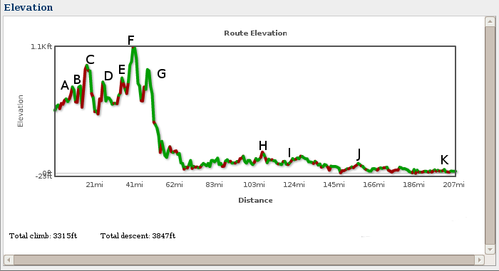
- A - mile 15, you've actually been climbing since you left the hotel. :-)
- B - mile 18, by the lake things get a little steeper
- C - mile 24, just outside Newton, there is a 'not short enough', steep hill. This hill will make you work. Actually you've been climbing for a while and you'll only notice it when you see the steep part.
- D - mile 26, Newton town square. Another short steep climb with a little traffic.
- E - mile 33, just after the tunnel.
- F - mile 38, the climb up to Rt 80 and beyond. After this climb there is one gorgeous descent (very fast).
- G - mile 47, Climb to Chester. Notice that after Chester the route descends until near mile 60. This is a good place to do pace lines but be careful as the traffic picks up here.
- H - mile 103, a short steep, rough hill outside Allentown on Extonville Rd. Stay near the left side of the lane.
- I - mile 124, a surprise uphill roller. Actually there is another short, little (50 ft long), steep climb at mile 127 after the Ranger Station. Neither are difficult.
- J - mile 160, Black Horse Pike over pass (yes that counts as a hill in South Jersey ;-) ). Nothing hard about this one.
- K - mile 203, Cape May Canal overpass. After 200+ miles this is a bit of a surprise.
- Really that's it!
Note that the mileage is not exact (I'm doing this from memory) and I may have missed a hill but this covers the big ones and the surprises of south Jersey where you're not expecting hills. For those of you who are real climbers some of my short steep climbs won't be a problem.
Hilly vs. flat rides
I've noticed that a lot of people who train for the Longest Day have been hill climbing as their primary method of training. While you do need to do some hill climbing and descent practice the real work is in the flat lands, the last 140 miles, that's 70% of this ride, is relatively flat. Most problems people have are heat, boredom and the mental/physical fatigue experienced on the lower leg. I think it might be better to train for both hills and really long flat, windy sections of Pine Barrens. Why? A lot of people think that a hilly ride is more difficult than a flat ride and while hilly rides are much more difficult than a flat rides there are a few things that most people don't anticipate. Flat rides are totally different from hilly rides. Because a flat ride is usually in an open field there is a lot of wind. Another fact about a flat ride is you'll pedal the whole way. With hills you can coast on the down hill but with flat ride you have to pedal the whole time.
Now let's add a ride into the Pine Barrens (that's really flat) and let's make it summer time (hot), mid-June (like on the Longest Day ;-). Now you have a couple of other interesting things. The first is usually heat. The Pine Barrens are usually warmer than other parts of NJ for a given day (as long as the sun is out). Also the roads are directly in the sun (little or no shade) which increases the heat index (how hot it feels). Often it's also a bit humid (though I don't know why, oh wait! It's a swamp.). And of course the last part that is purely psychological, the scenery in the Pine Barrens is pretty much the same. There are very few homes, very few people and one tree pretty much looks like the rest (Scrub Pine or Pin Oak). You are now dealing with heat, boredom and wind. These factors take many folks by surprise. Hill training does not prepare you for this. So remember to mix up the training. I have a number of routes I've posted on Bikely.com so use those as a reference.
The days before the ride
- About two weeks before the ride have your bike in for minor a tune up. Major work should be done a least a month before. Remember this is a shop's busy time of season. Wait too long and you won't be riding!
- At least a week before the ride, make sure you check the tires for tiny slits and shards of glass or radial tire wires. Replace the tires as needed.
- Two days before, in the morning pump up your tires fully. Then check them that night and see how well they're holding air. If you have a slow leak replace it now and shampoo, lather, repeat.
- Wash your bike and give it a light waxing. It makes it look nice and resist picking up dirt.
- Make sure your bike is properly lubed and everything is working smoothly. If you had it in for a tune up then there shouldn't be too much work to do.
- Make sure everything is properly secured. Tape down loose wires, tighten any loose bolts or nuts. Now is not the time for adjustments. That should have been done weeks ago.
- The day before make sure you pack your bags correctly. Bike shorts, shirts, shoes, creams (like chamois cream, I highly recommend it), socks, gloves, and helmet. Make sure you have your underwear, normal socks, shirts, pants, and shoes. I recommend a change of cycling clothes for the lunch stop. Clean clothes and socks feel wonderful and really make it seem like a new ride instead of just the second half of a double century. If you can find large zip lock bags then use them to separate items to make them easy to get at and find. If all your mid-ride clothes are in one bag you can grab the bag and change in a few minutes. Also those stinky clothes you were wearing well now they can go in the bag and not mess up anything else.
- Extra things to bring (if you have room): sun block (very important), lip balm, handi-wipes for quick clean up, toilet paper (hey it may save your butt :-), paper towels, bug spray because the Light House at Cape May is a mosquito resort town and you're the main course. Also cleaning cloths for any heavy clean-ups.
The day of the ride
- Relax! You've done your training and today you should just ride. If you've trained properly your body knows what to do. If not, well, ouch!
- Take advantage of your SAG wagon. Don't carry anything extraneous. Keep one extra tube, an air pump and your tire irons. A cell phone is a good idea pre-programmed with the SAG wagon's cell phone number and an ID to identify yourself in case you can't speak. Also make sure that the phone is fully charged and turned on (same goes for your SAG, doh!).
- Drink lots, often and eat small amounts often, on this day you'll really need it. It might not be a bad idea to periodical call out 'drink' every once in a while.
- Remember to downshift at the lights and stops. Practice this on your training rides. After a few hours your mind will wander and you'll forget to downshift. If it's a habit then you'll do it unconsciously. It's also another good thing to call out while stopping for a light ("Downshift, Downshift, Downshift"). Trust me it will save your knees and some strength on this long ride.
- Make sure you have at least a water bottle (2 is better). I ride with 2 water bottles and a 3L Camelbak for the Pine Barrens. I fill the water bottles with straight water and dump it on my head to cool off. Even warm water can cool on a hot day.
- Everyone not following the cue sheet shouldn't be looking at their mileage. Average speed is OK but try to ignore distance and time (except at stops and pace line pull duration). Try to let your mind enjoy the scenery and enjoy the ride. In the Pine Barrens see if you can smell the pines, see the animals (yes they're there hiding), feel the breeze on your face and the sweat glistening on your arms (Okay, Sandy you can stop with the 'Do you know how I know you're gay?' comments ;-). It really makes the ride more enjoyable. My team generally can ignore the cue sheet as I have it memorized but one of my fellow riders does double check me as I suffer from the doldrums like everyone else and have been know to take a wrong turn (usually caught quickly). But only once, in 2006, and it was only one out of about 150 instructions, not too bad. We still have a good laugh at my expense on that one.
- Have a good sense of humor and don't push the bounds of 'good taste' within the group. As you begin the second half, tension will be higher and the slightest annoying things will get amplified. People get tired and cranky so be careful.
- If someone is starting to annoy others then let them know about it early in a quiet way. The sooner the better.
- Enjoy the scenery it really is lovely. There are lots of farms, domestic animals and wild animals. But ...
- ... don't day dream and forget you're in a pace line. Pay attention to what's going on around you. If you've trained properly then your body will be on auto pilot and your mind can wonder a little bit.
- While in a pace line, try to see what's going on in front of the person in front of you. This may give you enough time to react and avoid a sudden situation.
- When it's your turn at the front of the pace line keep a watchful eye out for trouble ahead. Not just a few feet in front of you but several yards ahead. This allows to react calmly and guide the group gently around the hazard. Also don't increase the pace. I find that when I get to the front if I down shift one gear I don't pull away from the group.
- If you're the person on the front of the pace line try to keep an even pace. Also don't stop pedalling or make position adjustments or anything else that might make the bike behave eradictly. Save all that for the back of the line.
- Wait until you are at the back of the pace line to adjust anything you are wearing, take drinks or eat food, stand up or anything else that might be unexpected. Doing something that suddenly causes you to slow down or causes your bike to shoot backwards is very dangerous to the riders behind you. When you are at the front keep pedaling. You can rest when you come off the front. If you're too tired to pull then get off the front sooner. Accidents happen when you're tired.
- Don't wear head phones or anything else that might hinder your hearing. It's illegal in the state of NJ! Though we usually look for cars we also listen for them. Though today's new hybrid cars can really mess that up as many are completely silent. It's very eerie to see them pass but not to hear them approach.
- Don't overlap the wheel of the rider in front of you. You will go down if the two of you bump and it will be your fault not the rider in front of you. Usually broken bones, bikes and helmets are the outcome of such a crash. This is the fastest way to ruin your ride and possibly everyone else behind you.
- If you are in a pace line and it begins to 'slinky' (speeds up, slows down, repeat) then back off the wheel in front of you some distance. This usually happens when someone is tired or the terrain changes. Either way it's the quickest way to get into an accident. Be careful!
- If while riding in the pace line you suddenly find yourself going off road first call it out so no one behind you follows. Second don't panic. Third sit up but don't tense up. By removing the weight off the front wheel you might be able to avoid driving the front wheel into the ground. Third don't hit the brakes. Try to ride through it but at a slower pace. If you can shift to a lower gear. This might help you spin through it.
- If someone goes down in front of you don't lock up your brakes. If you do you might fall directly on top of them and the riders behind you may end up doing the same. It may be a better idea to ride over them (if you can). Try not to panic.
- Don't fix your attention on the wheel in front of you. Instead try to see what's going on further down the road or several riders up. This will give you some time to react to a situation.
- Notify the ride leader of anyone that is either not well or having difficulty with the pace.
- If you can't keep the pace then don't take a pull at the front of the pace line or shorten your turn. Usually everyone wants to do their fair share of the work but sometimes you can't. When your turn comes just carefully pull off the front of the pace line. Or, worse case, stay at the back of the pace line.
- When coming off the front of the pace line announce to the rider behind you that you are coming off the front. This way the rider behind you doesn't follow you making it impossible for you to come off the front.
- Ride within yourself. If you're the one who can't keep the pace be mindful of others. Letting folks know early allows your team to drop the pace a little bit. This could be the difference between completing the ride on the bike or in the SAG. The scenery is much better on the bike. Other times they could allow you to hang at the back to rest up. If you can't handle either then it's time to put your ego aside and just say you can't finish the ride. Don't ruin it for everyone. If you have a good team they'll slow down and help you complete the ride.
- Remember that this is a 200 and 8 mile ride. On my first ride I was so excited to see 200 miles and was promptly disappoint by not seeing the Light House. I was so worked up about seeing the Light House at 200 miles that the last 8 miles were my least favorite part of the ride. I now finish the ride with the strength to go another 60 miles, except I can't swim. ;-)
Every stop
Our stops are usually kept short, this is important early on as it means that you'll pass through the Pine Barrens earlier in the day (yes every minute counts). We've found that 10 to 15 minutes works well and it doesn't let your muscles tighten up. Which in turn means that you won't need to warm up your muscles again and can get back into a pace line quickly.
- While pulling into the rest stop downshift to an easy gear. It's better to downshift to a 'too easy' gear than it is to a 'too hard' gear. Remember that you will stiffen up a bit at rest stops.
- Refill fluid into your Camelbak and/or bottles. Keep one bottle just water for dumping over your head in the heat of the day. As I've said I carry extra water in the Pine Barrens for this purpose. My main fluid source is my Camelbak.
- Eat a little something, a banana, a power bar, something. On this day you won't be able to replace the calories you burn. Don't push your luck with too large a deficit by not eating or waiting until you're hungry. Then it's too late.
- Conversely, don't eat too much all at once. When you are riding hard food tends to sit in your stomach undigested. This can lead to digestive distress (gas, pain and/or queasiness).
- Vary your diet (food/drink) through out the day. If you eat the same thing all day long your digestive system will get bored and that usually leads to rumbling, gas or worse
- A quick check of your tires for debris stuck on or in the tire and check for slow leaks.
- Potty breaks - Smoke'm if you've got'em! Restrooms, that is. There are many places (WaWa's, parks, etc.) where you can stop but don't get nasty with small stores that don't have public rest rooms. I don't recommend roadside stops in the Pine Barrens. There are ticks, snakes, mosquitoes and swamps. Even a port-a-potty beats hiding behind a tree. Besides it gives you a chance to see if you're drinking enough. If your urine exits dark and foul (you won't need to put your nose in it to know) then drink more fluids, NOW! If it's light to clear then you're fine. In between, adjust accordingly. If you can't go then you're probably not drinking enough. On one really hot day (105F) we rode 100 miles, needed no pee breaks, sweat like mad and drank like fish. I suffered from dehydration for the next 3 days. I must have drank about 11L of fluid that day. I don't recommend riding on a 105F degree day.
- Have a sore back, shoulders and/or neck from riding in a tuck too long? One solution is to lay down on hot asphalt (but not in traffic). The heat from the road will do wonders for your muscles. Thank Gina Lipman for that one! :-) You might want to cover your face with a cool wet towel to cool your face off. That way you won't overheat.
- Before leaving a stop make sure you've already down shifted before you get on the bike. You really should have down shifted as you came into the stop but you may have forgotten.
The Lunch stop
Our lunch stops tend to be a bit longer but we're trying to do a lot more here. In the past we've kept them to 45 - 60 minutes and that's worked well. This year we're trying 30 minutes (worked well in 2005 and 2007) with an additional 30 minute break 2 stops later once we're past the worst of the Pine Barrens. We're hoping that the shorter stops will be more forgiving on our muscles. As the longer the stop the more your muscles will tense up. We're also saving 15 minutes in over all time (old = 60 + 15 min for 2 stops vs. new = 30 + 30 min. for 2 stops).
- We like to eat 'normal' food. Ice Cream, subs, cookies and/or cake. But never eat too much, save it for the next stop. And don't experiment with new food the day of the ride. Having food sit in your stomach, undigested, is a sure way to upset your digestive tract. That can lead to a shortened ride.
- In addition to eating a (slightly) larger meal at lunch. Pump up your tires to full pressure.
- Use the rest room!
- Wash up, you'll feel more comfortable. Even rinsing your hair might not be a bad idea. Getting the sweat out of your hair and off your face means it won't get in your eyes later. It should at least cool you off.
- Change your clothes and your socks. It will make it seem more like a new ride.
- Re-apply sun block (every 2 hours) or sooner if you sweat heavily.
- Re-apply chamois cream to your shorts.
- Keep it short so as not to let your muscle become too tight.
- You might want to put away that phone, it may eat up valuable time that could be used to shove food in your mouth.
Aches, pains and sores
I'm not a doctor so don't look for medical advice here! I can only tell you what I've done for the minor aches, pains and sores I've gotten. Usually I just ride through them with nothing more than a pain reliever. For any open wounds make sure you keep it clean. If it continues to bleed then stitches are needed. Stomach problems are tougher to treat. So far I've not been successful. If you get diarrhea or nausea then get off the bike. Do not try to finish the ride unless you only have a few more miles to go. You can do a whole lot of damage to your internals when you get dehydrated!
- For mild muscle aches and pains take aspirin or another pain reliever. I tend to take something within the last 25 miles as I know that once I'm off the bike I'll start to stiffen up and get sore.
- Road rash or a scab in the wrong spot? Try neosporine, I find that neosporine keeps the area soft and flexible. When cyclists fall they tend to scrape areas that need to move.
- Saddle sores, Remember to keep the area clean. What I like to use on rough sores is diaper rash creme. It keeps the raw area from stinging and it acts as a lube. I use it in addition to chamois creme not instead of it. This won't solve those pimples that can develop. To minimize saddle sores try not to slide around on your seat so much. I don't know what to do once you've gotten the sores. I just ride though it (Pain heals. Chicks dig scars. Glory ... lasts forever.).
- Mild hemorrhoids, keep the area clean with anti-septic wipes and then a small dab of hemorrhoids creme. If it swells too much or you get blood, get off the bike. I don't think cold water is a good idea as it's not really swelling. Soaking in a warm bath seems to reduce them (when you're off the bike of course :-). Avoid sitting on cold steel or cold concrete. My father was an Iron Worker and he told me that both made them worse.
- Hands go numb, try moving your hands to other positions on your handle bars at regular time intervals. You can even do a superman stretch by putting the palms of your hands on the hoods of your brakes. Use as much of the handle bar as you can that's what it's there for. Giving your arms and hands a good shake every once in a while is not a bad idea either.
- Numb or burning feet, loosing the straps/laces or try moving your clips fore or aft of their current position. You could be hitting a nerve in your foot and putting it to sleep. On the Longest Day a little loose is a good thing.
- Numb nuts (sorry ladies), point your saddle down more or get one of those saddles with the cut outs. I use a Brooks saddle (no cut out) and it's pointed abruptly down. Probably not recommended but I'm comfortable with the setup.
- Sore shoulders and neck, either bring up the nose of your saddle or add push ups and neck exercises to your exercise plan. Since my saddle points nose down, my shoulders and neck take the brunt of the force. Training exercises during training season may help to avoid this. Push ups, sit ups and crunches may help as they keep the core muscles strong which avoid using other muscles to take up the slack.
- Muscle pulls, while riding you can either ride through the pain, but at a lesser pace or get off the bike. I've ridden through them but I'm not sure that was the wisest idea. Spinning an easier gear may help some but you will tire in a different way.
- On a ride of this length your butt may feel numb or tired. One way 'to get the blood flowing again' is to simply stand up. If you are in a pace line wait until you get to the back of the line or when you are falling to the back of the line. When you stand up the bike will suddenly shift backward several inches and you could overlap wheels with the folks behind you (VERY BAD!).
External Links
In no particular order:
- Central Jersey Bike Club (CJBC)
- Longest Day 2005 route - This is the route using Google Maps @ Bikely.com. You can also find the cue sheet and elevation map of the ride.
- Bikely.com - This is where I put all my ride cue sheets. It works well with Firefox and IE but needs Javascript turned on and Macromedia Flash makes it work a little better.
- My Routes - these are just some of my routes I've entered. I have several more that I'm working on. I know I have a least 75 different routes as I entered them on another site but that site seems to be falling apart and I can't export them directly to here (grrr!).
- My Planning page (requires Javascript) so you can plan out your rest stops and what time you might expect to be at certain mile markers on the route.
- Here's a link form the Ultra Cycling folks (they do long distance cycling to the extreme!). UCMA Preparation for a Double Century. Lots of good information.
- Another UCMA link on Eating For a Century, Brevet or Double Century