
208 miles in one Day
(Last updated: Thu. Sep 24, 2009)
The Longest Day, the ride
The ride
![]() I love this ride, so much so I'm the 2010 Longest Day chairperson,
and I'm a bit of a mileage junkie. I need miles but I need to keep
them to a single day. Otherwise I'd be doing brevets, like
Boston-Montreal-Boston or Paris-Brest-Paris, both 1200 km. There's
nothing like saying that you've completed a double century as part
of your list of riding accomplishments. Besides it's a lot of fun
to watch non-cyclists do a double take when you tell them. One
important thing to note, this ride is not 200 miles it's 208
miles. Those extra 8 miles can really beat you up mentally if
you're not expecting them.
I love this ride, so much so I'm the 2010 Longest Day chairperson,
and I'm a bit of a mileage junkie. I need miles but I need to keep
them to a single day. Otherwise I'd be doing brevets, like
Boston-Montreal-Boston or Paris-Brest-Paris, both 1200 km. There's
nothing like saying that you've completed a double century as part
of your list of riding accomplishments. Besides it's a lot of fun
to watch non-cyclists do a double take when you tell them. One
important thing to note, this ride is not 200 miles it's 208
miles. Those extra 8 miles can really beat you up mentally if
you're not expecting them.
Oh for 2009, I managed to cut off 1.5 miles (woo-hoo!). For 2010 we may be adding a few miles (+2.5? boo-hoo.)
Mike Kruimer (retired CJBC President) likes to say that the Longest Day is "All down hill". That means it's more down hill than up hill. My team should average about 17 mph for the entire ride. Since a few of us are poor climbers that means we're slower on the first half than on the last half. There are no real killer climbs on the ride. There are one or two surprises such as a short nasty climb outside Newton, a short up hill roller before the Ranger Station and the bridge over the canal in Cape May. There are long climbs and as long as you keep a steady pace you should do fine. The descents are fast and it's easy to hit speeds in the 40's (mph) without too much effort. There are a few locations where traffic becomes a concern.
I have completed 8 Longest Days, 2001 @ 15.8 mph to 2004 @ 17.8 mph. 2005 we had too many people (9) and we finished late (8:45 PM) @ 17.5. In 2008 we almost arrived late but a strong final kick on the last 24 miles brought us in at 8:28 pm. For 2009 we cruised to a 17.5 mph avg despite it being an off year for me. I give credit to Jud Hand for keeping us within our limits (thanks Jud). Here is my planning page to work out a plan for the Longest Day (requires Javascript). Try changing the average speed and see what it does. Or change the stop times. It's not perfect and I probably need to add a few more features but it mostly works. Here's the Route Page with the links to the cue sheet. I hope to have the unofficial alternate route to the High Point monument. I've laid it out and now I need to add the turns and street names.
In the next section (below) you'll read my view of the ride (exaggerated for a little levity). Understand that I enjoy the heat and the Pine Barrens. It is meant to be humorous so don't take anything as a critism or negative comment. Also I've try to note the changes as the years go by but it's a little tough to do. So if the mileage is off at certain location it's because we've (my team) has adjusted our stops to better suite our needs.
 Oh 400 or Oh my God! How early?
 We start out at 4 AM. It's usually cold, about 40 - 45F, though we
have seen it as high as 75F (a tropical storm) and as low as
35°F (it still hit 90+°F in the Pine Barrens). It's also
before sun rise so you'll need lights. Our SAG wagon followed us
with the high beams on so we have a general view of what's around
us. Bike lights are still a must as they light up the road
directly in front of you (the SAG can't). I also find that a cheap
pair of safety glasses are a good idea as it keeps junk out of
your eyes. Mine are either clear or amber. Amber really works
well. We need to be on the look out for bears (really), deer, and
skunks. The first section is a set of rollers which can be
annoying as the road twists and turns so you'll loose the SAG
wagon lighting your way from time to time. At sunrise you might
have to deal with fog (the sun is stuck in North Jersy traffic
;-). Once the sun is up you'll begin some of the climbs that are
on this route. As the sun rises so does the temperature. The nice
thing about the climbs is that you'll begin to warm up more as you
climb. On the way down a refreshing breeze will cool you off
nicely (40F - 40F wind chill @40 mph ... bring a sweater!). The
really nice thing about the descents is that they're fairly
straight, the traffic is light and the roads are clean. You can
hit pretty descent speeds on the descents. Shortly after the sun
has risen we like to get rid of the extra gear and clothes. In the
past we've dumped all our extra clothing and lights when we hit
Newton (mile 26.8). In 2009 we've decided to stop at the Andover
Diner (mile 32) instead of Newton. This allowed us to drop one
stop, even out the distances (around 33 miles between stops) and
get some hot food and coffee. They also have a working rest room
which is a plus (beats a tree any day :-).
We start out at 4 AM. It's usually cold, about 40 - 45F, though we
have seen it as high as 75F (a tropical storm) and as low as
35°F (it still hit 90+°F in the Pine Barrens). It's also
before sun rise so you'll need lights. Our SAG wagon followed us
with the high beams on so we have a general view of what's around
us. Bike lights are still a must as they light up the road
directly in front of you (the SAG can't). I also find that a cheap
pair of safety glasses are a good idea as it keeps junk out of
your eyes. Mine are either clear or amber. Amber really works
well. We need to be on the look out for bears (really), deer, and
skunks. The first section is a set of rollers which can be
annoying as the road twists and turns so you'll loose the SAG
wagon lighting your way from time to time. At sunrise you might
have to deal with fog (the sun is stuck in North Jersy traffic
;-). Once the sun is up you'll begin some of the climbs that are
on this route. As the sun rises so does the temperature. The nice
thing about the climbs is that you'll begin to warm up more as you
climb. On the way down a refreshing breeze will cool you off
nicely (40F - 40F wind chill @40 mph ... bring a sweater!). The
really nice thing about the descents is that they're fairly
straight, the traffic is light and the roads are clean. You can
hit pretty descent speeds on the descents. Shortly after the sun
has risen we like to get rid of the extra gear and clothes. In the
past we've dumped all our extra clothing and lights when we hit
Newton (mile 26.8). In 2009 we've decided to stop at the Andover
Diner (mile 32) instead of Newton. This allowed us to drop one
stop, even out the distances (around 33 miles between stops) and
get some hot food and coffee. They also have a working rest room
which is a plus (beats a tree any day :-).
Just outside Andover, around mile 33, is an interesting feature, a tunnel! For the extremely childish among you, it should be noted that this tunnel makes an excellent echo chamber. ;-) After the fun of the echo chamber there are a few more climbs before you reach Cranberry Lake and Stanhope.
Stanhope/Netcong Near Rt 80
 Generally the worst section of traffic is in Stanhope (mile 37.8),
near Rt 80. You want to get here as early as possible and avoid
the initial part of a Saturday morning rush hour. The reason is
that you must cross 2 lanes of traffic to use the left exit ramp
(from Rt 206 to Rt 183 into Netcong). We tend to get there before
7 AM and that seems to work well. We just catch the beginning of
the rush hour. The next challenge is the climb out of Netcong. You
have the Rt 46 circle (with an underpass) and then Rt 80. There
seems to be a reasonable shoulder but the traffic is fast so it's
not the most comfortable of places to ride. After you finish the
climb there is the decent into Flanders . It's a great descent
except for the traffic light mid-way (with a sewer grate where
you'll be riding). The light is usually red (grrr!).
Generally the worst section of traffic is in Stanhope (mile 37.8),
near Rt 80. You want to get here as early as possible and avoid
the initial part of a Saturday morning rush hour. The reason is
that you must cross 2 lanes of traffic to use the left exit ramp
(from Rt 206 to Rt 183 into Netcong). We tend to get there before
7 AM and that seems to work well. We just catch the beginning of
the rush hour. The next challenge is the climb out of Netcong. You
have the Rt 46 circle (with an underpass) and then Rt 80. There
seems to be a reasonable shoulder but the traffic is fast so it's
not the most comfortable of places to ride. After you finish the
climb there is the decent into Flanders . It's a great descent
except for the traffic light mid-way (with a sewer grate where
you'll be riding). The light is usually red (grrr!).
Chester to Bridgewater
 The next section is Rt 206 between Chester and Bedminster and at 8
AM in the morning it's rush hour so you will be sharing the road
with cars. The shoulder is reasonable though the traffic speeds
are fast. The nice thing about this section is that if you have a
good team this is the first place to really pick up time. Its
mostly a down hill ride (see the Hills
diagram below, it's hill G). After climbing out of Flanders
(the hill up to point G) the rollers start and they're great for
pace lines. You can really get going here and pick up some of the
time you might have lost on the climbs. In 2008 they paved the Rt
206/Rt 287 underpass. The sewer grates are still there but the
pavement is so much nicer!
The next section is Rt 206 between Chester and Bedminster and at 8
AM in the morning it's rush hour so you will be sharing the road
with cars. The shoulder is reasonable though the traffic speeds
are fast. The nice thing about this section is that if you have a
good team this is the first place to really pick up time. Its
mostly a down hill ride (see the Hills
diagram below, it's hill G). After climbing out of Flanders
(the hill up to point G) the rollers start and they're great for
pace lines. You can really get going here and pick up some of the
time you might have lost on the climbs. In 2008 they paved the Rt
206/Rt 287 underpass. The sewer grates are still there but the
pavement is so much nicer!
Between Rt. 287 and Foothill Rd the road isn't too bad. Once you're off Rt 206 in Bridgewater traffic drops off. Watch the road condition as it's getting much worse over the years. It picks up again as you cross Rt 287 between Finderne and Manville. Again you'll be dealing with 'in town traffic' in Manville. They're resurfaced the bridge roadway so it's much nicer. In 2010 we changed the route to avoid the second Foothill Rd. section. For 2011 we'll be looking at this section again to see if reasonable repairs have been made or not. We'll definitely take the better of the two roads.
Finderne/Manville
After a few traffic lights you'll approach the bridge between Finderne and Manville, over the Raritan River. After the bridge is the town of Manville and there is gas, food and restrooms available here.
Manville/Griggstown Canal/Kingston/Plainsboro
 Outside Manville pace lines can begin again. Especially when you
get to Canal Rd. The double metric starts somewhere around
here. Just be careful as the roads are narrow and because it's a
chip seal
road it may be a bit slick. Especially if the tar has risen.
Anyway, welcome to the start of the flat lands. From here on to
Cape May there are no long climbs (though there are a few
surprise, short, steep climbs later). You'll pass through
Millstone, Griggstown, Kingston, Plainsboro and West Windsor with
light traffic. In Plainsboro you'll return to sharing the road
with moderate traffic but the roads are a bit wider.
Outside Manville pace lines can begin again. Especially when you
get to Canal Rd. The double metric starts somewhere around
here. Just be careful as the roads are narrow and because it's a
chip seal
road it may be a bit slick. Especially if the tar has risen.
Anyway, welcome to the start of the flat lands. From here on to
Cape May there are no long climbs (though there are a few
surprise, short, steep climbs later). You'll pass through
Millstone, Griggstown, Kingston, Plainsboro and West Windsor with
light traffic. In Plainsboro you'll return to sharing the road
with moderate traffic but the roads are a bit wider.
 Around mile 88 is the
Grover's Mills that is mentioned in H.G. Wells "War of the
Worlds". Supposedly the barn building on the left is the landing
site and behind it (hidden) was the shot up water tower. ... So
far the winds have either been mostly West or South West. The next
20+ mile section is a mostly west-east ride towards Allentown
which means that just before Allentown/lunch (Food!) a
bit of speed can be picked up as well as doing pace lines. Don't
over do it as you still have about 110 miles left after
Allentown.
Around mile 88 is the
Grover's Mills that is mentioned in H.G. Wells "War of the
Worlds". Supposedly the barn building on the left is the landing
site and behind it (hidden) was the shot up water tower. ... So
far the winds have either been mostly West or South West. The next
20+ mile section is a mostly west-east ride towards Allentown
which means that just before Allentown/lunch (Food!) a
bit of speed can be picked up as well as doing pace lines. Don't
over do it as you still have about 110 miles left after
Allentown.
Allentown, Lunch!
 Just before Allentown you'll cross the Rt. 195 overpass, welcome
to south Jersey! The century ride starts around here. My team will
arrive in Allentown around 10:30 AM, eat, clean up and prep the
bikes for another hundred. We want to leave here relatively
quickly as the next part of the ride begins the Pine Barrens and
the heat. Of course we still need to have a few minutes off the
bike as we've just completed a century (congratulations! Except
for those who are doing the century and double metric, No soup
for you! ;-) ).
Just before Allentown you'll cross the Rt. 195 overpass, welcome
to south Jersey! The century ride starts around here. My team will
arrive in Allentown around 10:30 AM, eat, clean up and prep the
bikes for another hundred. We want to leave here relatively
quickly as the next part of the ride begins the Pine Barrens and
the heat. Of course we still need to have a few minutes off the
bike as we've just completed a century (congratulations! Except
for those who are doing the century and double metric, No soup
for you! ;-) ).
 BTW, the gentleman in the photo was in Cape May when the photo was
taken. I just didn't have any good photos for Allentown. If you
hover your mouse over the photos you should see my caption. I
think every photo on the page has something.
BTW, the gentleman in the photo was in Cape May when the photo was
taken. I just didn't have any good photos for Allentown. If you
hover your mouse over the photos you should see my caption. I
think every photo on the page has something.
The Pine Barrens
 Between Allentown and the Ranger Station is Ft. Dix Military
Reserve, Browns Mills and Lebanon State Forest. In some sections
the roadway is nicely shaded. There are many farms, the scenery is
nice and the traffic low. There's one surprise rolling uphill just
after the turn onto Upper Mill Rd (mile 123). Then you cross Rt.
70 to the Ranger Station. This is a good place to stop, hit the
restrooms and wash up quick. Once past the Ranger Station (we
usually arrive around 12 - 1 PM) there is no relief from the
sun. Shortly after this you will see the last of the vestiges of
civilization (Chatsworth).
Between Allentown and the Ranger Station is Ft. Dix Military
Reserve, Browns Mills and Lebanon State Forest. In some sections
the roadway is nicely shaded. There are many farms, the scenery is
nice and the traffic low. There's one surprise rolling uphill just
after the turn onto Upper Mill Rd (mile 123). Then you cross Rt.
70 to the Ranger Station. This is a good place to stop, hit the
restrooms and wash up quick. Once past the Ranger Station (we
usually arrive around 12 - 1 PM) there is no relief from the
sun. Shortly after this you will see the last of the vestiges of
civilization (Chatsworth).
Chatsworth

 After crossing Rt 72 the route turns south, the roadway is wide
and long (13.8 + 5.4 or 19.4 miles) and there is little tree
cover. In about 4 miles you will pass through Chatsworth. There's
a lovely General Store there but it's a novelty shop (?). The last
thing you will see before leaving town is the Chatsworth cemetary
(note to editor, play ominous music here). This is the last
vestiges of civlization as you head into the heat of the Pine
Barrens. While I love the heat most of the other folks I ride with
can suffer pretty badly. BTW, those bleach bones along the side of
the road are not deer, they're the remains of the ghost rider. :-)
In the past, I've recommend adding a stop 22.2 miles (~2:30 PM)
after the Ranger Station to give rest, fill up on fluids, grab
some food and to get out of the sun.
After crossing Rt 72 the route turns south, the roadway is wide
and long (13.8 + 5.4 or 19.4 miles) and there is little tree
cover. In about 4 miles you will pass through Chatsworth. There's
a lovely General Store there but it's a novelty shop (?). The last
thing you will see before leaving town is the Chatsworth cemetary
(note to editor, play ominous music here). This is the last
vestiges of civlization as you head into the heat of the Pine
Barrens. While I love the heat most of the other folks I ride with
can suffer pretty badly. BTW, those bleach bones along the side of
the road are not deer, they're the remains of the ghost rider. :-)
In the past, I've recommend adding a stop 22.2 miles (~2:30 PM)
after the Ranger Station to give rest, fill up on fluids, grab
some food and to get out of the sun.
Jenkins
 In 2010, we found ourselves dealing with a headwind that
progressively got worse the further south we went (started in
Manville at mile 60). We decided that perhaps a better idea was to
take a break 10 miles into the middle of the Barrens, in Jenkins,
at Mick's Canoe Rental. While it doesn't look like much they do
have non-cyclist foods. Remember this around mile 140 and the
middle of the Doldrums. Even a small break is a welcome one. This
mostly worked well for us except for the fact that shortly after
returning to the road we caught a large group of cyclists who were
doing only 14 mph. The 4 members of our team ended up dragging
20-n-some-odd riders the last 10 miles through the Barrens. We
thought about accelerating and dropping them but we also knew that
we had 60 miles of increasingly stronger winds to come. We made
the wise choice and sucked it up rather than dragged on at 14
mph. We then pulled the pace line but at less than 20 mph.
In 2010, we found ourselves dealing with a headwind that
progressively got worse the further south we went (started in
Manville at mile 60). We decided that perhaps a better idea was to
take a break 10 miles into the middle of the Barrens, in Jenkins,
at Mick's Canoe Rental. While it doesn't look like much they do
have non-cyclist foods. Remember this around mile 140 and the
middle of the Doldrums. Even a small break is a welcome one. This
mostly worked well for us except for the fact that shortly after
returning to the road we caught a large group of cyclists who were
doing only 14 mph. The 4 members of our team ended up dragging
20-n-some-odd riders the last 10 miles through the Barrens. We
thought about accelerating and dropping them but we also knew that
we had 60 miles of increasingly stronger winds to come. We made
the wise choice and sucked it up rather than dragged on at 14
mph. We then pulled the pace line but at less than 20 mph.
Green Bank/Mullica

If you do try to do the whole 20 mile Chatsworth section in one shot, try to find a shady spot to stop. In 2008 (hot and humid) at least 7 teams seemed to all meet up at the Rt 563/Pleasant Mills Rd stop sign in Green Bank. This is the end of the first part of the 'doldrums'. It's not usually too bad as you've probably just gotten off the earlier lunch break. If it's hot (90+F) this section will be brutal. Take into account the heat index and add 10F for the heat reflected off the road. Oh, you'll probably notice a change in direction in the wind. Get used to it you'll feel it the rest of the day. ;-)
May's Landing
After this stop we plan another stop 20 miles (~4 PM) further down the road, after the Atlantic City Expressway, in May's Landing (McDonald's = bathroom and a cool milk shake, AHhh!). Yes we skip Egg Harbor as it's too soon after our last stop. For 2010 I may make an adjustment that may help. Now that you're out of the worst of the Doldrums you'll soon be crossing over the Mullica River. In a few miles you'll find civilization again in the form of Egg Harbor. A lovely town with a wide main street and angled parking. A little disconcerting but a welcome sight.
The next section, AC Express Way (mile 156) - May's Landing (mile 162) - Woodbine (mile 184) is again what I refer to as the second doldrums. It's where weariness sets in. You're physically tired, mentally tired and possibly emotionally drained. The scenery doesn't change and it's kind of bland (well after almost 160 miles it's kind of bland). This is where emotions can flair and mistakes can be made. Like overlapping the wheel of the rider in front of you. Instead of that excitement a shot of caffeine might not be a bad idea but back it up with some liquids and some carb's. Be careful here!
For 2009 we had to adjust the route due to some construction in Tuckahoe. I managed to cut off around 1.5 miles off the route. Unfortunately I also managed to remove a favorite stop, the Ice Cream Barn. Team Ride to Eat has not forgiven me for that gaff. My only solace is that I ride faster than they do and they're not likely to catch me anytime too soon.
The Jersey Devil

While on the topic of the NJ Pine Barrens let's add a word of caution. You already know to be wary of snapping turtles, bears, cougars, coyotes, pine flies, mosquitoes, ticks, snakes, the decaying remains of mob hits and to keep your fingers away from a cyclists mouth. Well there is one more thing to add to your list; the NJ Pine Barrens is also home to the Jersey Devil. To this day people swear that they've seen it (it was on the history channel recently, they never lie!). In 1909 the Devil went on a week long rampage where it was seen as far away as Philadelphia (I hear the zoo is quite nice). It was last seen in NJ in 2007. While little is know about the Jersey Devil what is known is that the Jersey Devil has taken a likening to cyclists. Seems that the chamois creme (Butt BUTT'r) is like steak sauce. So meddle not in the affairs of the Jersey Devil for you are crunchy and good with ketchup, er Butt BUTT'r! ;-)
")
Dennis/Woodbine/Cape May Court House
Something about this section picks up the spirit and changes the mood of the ride. Probably it's the name, Cape May Court House, the other reason is that you're out of the 'Doldrums'. It might even be that you only have about 23 miles to go. This is a good place for a stop at a near by WaWa (they have bathrooms, drugs - like ibuprofen, and junk food what more can you want ;-). You still have about 25 miles to go and you'll probably experience a head wind. Ignore the head wind, do pace lines and don't push too fast. Be prepared for at least one more short, steep climb over the Cape May canal (who put that mountain here!) at around mile 203!
One other thing I'd like to point out. As it is getting later in the day and graduation season is upon us, keep in mind that the traffic picks up here and that a number of the cars could contain high schools graduates (and all which that entails). Also don't be surprised at a number of people just honking to say hello. That's something that has always surprised me in this section, the number of people who honked and waved. Or it could be that I'm hallucinating. ;-)
200 Miles! (Rio Grande, NJ)
Surprise! No Lighthouse! Remember that the Lighthouse is at 208 miles not 200 miles. You still have a little bit of a distance to go (30 minutes at 16 mph avg speed). At around mile 203 you'll have the last mountain to climb. It's the bridge over the Cape May Canal. After nearly 100 miles of no climbs this is quite a surprise. As I recall, from my first Longest Day: "Oh my god, who put that mountain there!". Don't worry you'll make it.

The Light House
Finally "The Lighthouse" is in sight but you still have 2.5 miles left to get there! So take it easy, keep your pace and you'll all make it in one piece. One important thing to note. When we've arrived at the lighthouse after 8 PM we've noticed a significant number of mosquitoes (even if it's windy!). But when we've arrived before 7:30 PM we haven't noticed the mosquitoes. Also stay away from the reeds (first parking lot). Away from the reeds the wind is stronger and the mosquitoes avoid a good breeze. Just food (which might be you) for thought when planning your ride!


You made it!
Well we did anyway, the photo left is the Team I was on in 2008. From left to right: Gina Lipman, Thos Cochrane, Sandy Somers, Mark Heck, and myself Neil Cherry. Really it's not as hard as one might think to do the Longest Day. It does require planning and training but once you've done it you'll be surprised that it wasn't as difficult as you expected. Obviously we weren't the only ones to make it as evidenced by the photo right.
Hills
As far as double centuries go this one is easy. That's mainly
because it's mostly downhill (total climb: 3315 ft, total descent:
3847 ft.). As I've said I'm not a climber so take these
descriptions from that prospective. Still there are a few hills
and non-hills of interest: 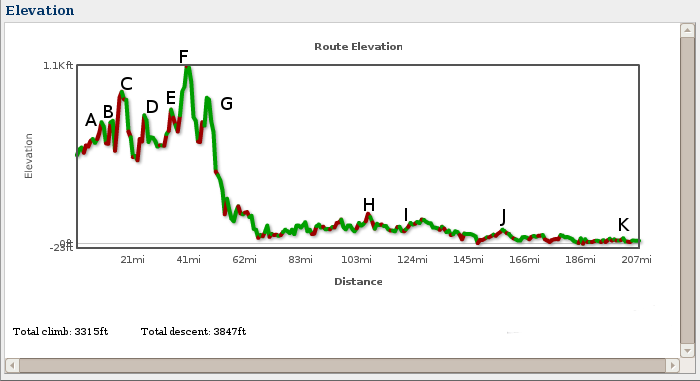
- A - mile 15, you've actually been climbing since you left the hotel. :-)
- B - mile 18, by the lake things get a little steeper
- C - mile 24, just outside Newton, there is a 'not short enough', steep hill. This hill will make you work. Actually you've been climbing for a while and you'll only notice it when you see the steep part.
- D - mile 26, Newton town square. Another short steep climb with a little traffic.
- E - mile 33, just after the tunnel.
- F - mile 38, the climb up to Rt 80 and beyond. After this climb there is one gorgeous descent (very fast).
- G - mile 47, Climb to Chester. Notice that after Chester the route descends until near mile 60. This is a good place to do pace lines but be careful as the traffic picks up here.
- H - mile 103, a short steep, rough hill outside Allentown on Extonville Rd. Stay near the left side of the lane.
- I - mile 124, a surprise uphill roller. Actually there is another short, little (50 ft long), steep climb at mile 127 after the Ranger Station. Neither are difficult. These are south Jersey Mountains! ;-)
- J - mile 160, Black Horse Pike over pass (yes that counts as a hill in South Jersey ;-) ). Nothing hard about this one.
- K - mile 203, Cape May Canal overpass. After 200+ miles this is a bit of a surprise.
- Really that's it!
Note that the mileage is not exact (I'm doing this from memory) and I may have missed a hill but this covers the big ones and the surprises of south Jersey where you're not expecting hills. For those of you who are real climbers some of my short steep climbs won't be a problem.
Terrain
As you can see the first 56 miles contain most of the hilly terrain. The next 10 miles contain small towns and homes with Manville being the largest of the group. Then from Manville to Kingston you're in a less densely populated area. With the canal being nicely shaded. Once you hit Kingston you're back in the urban sprawl and corporate complexes until you hit Allentown. Once you leave Allentown you're in lightly populated areas with wide tracts of farm and horse acreage. The roads in this area are sparsely shaded. Just before Ft. Dix you'll enter Cookstown (don't blink). In Ft Dix you'll notice the trees change over to more Pine Scrub. This is the start of the Pine Barrens.
In Ft. Dix there is very little shade (an omen of things to come). After Ft. Dix you'll enter Browns Mills. Pretty much this is the last vestiges of civilation until Egg Harbor. Once on Four Mile Rd (New Lisbon) you are again in the Pine Scrub though there is shade here. After about 4 miles on Four Mile Rd you'll turn left, a little while later, you'll cross Rt 70 and a little bit more and you're at the Rangers' Station. Basically from here until you reach the Mullica Bridge (about 24 miles) there will be no relief from the sun.
A few miles after the Mullica Bridge you'll enter the town of Egg Harbor. It seems like something out of the late 50's or early 60's but it is a welcome sight. After leaving Egg Harbor you'll venture down the road a few more miles to May's Landing and then the final section of Pine Barrens (about 10 miles), a couple of turns, some more Barrens (about 7 miles) with turns and finally Woodbine, Rt 47 and The WaWa. This landmark (the WaWa) means you only have about 24 miles to go! It also means you're out of the Pine Barrens. Traffic picks up here but so can your pace. :-) One last hill (mile 203) at the Cape May Canal and you're now feeling the finish (and a few other things ;-). Oh congratulations you've already completed a double century! Finally you make the turn onto Sunset Blvd and you can see the Lighthouse, another 2.5 miles and you're done!
Wind
The wind in NJ, during the summer, on a warm day is generally from the south and west. (You're riding from the north to the south so you figure it out. :-) For most Longest Day rides that's the wind you'll get. As you travel from the north to the south the wind will gradually increase. So by the time you get to the Pine Barrens you may notice something. Unusual weather patterns mean more or less wind (2001 - a tropical storm, more wind, 2002 - rain all day, little wind, 2010 - wind became noticable at mile 60, insufferable wind and white caps in Cape May (no really)). My best advice is to work the pace line but be careful when riding with a group you are unfamiliar with. Especially later in the ride when everyone is tired. Generally the best thing to do is to ignore the wind as you can't really do much about it.