
208 miles in one Day
(Last updated: Thu. Sep 24, 2009)
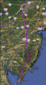 The Longest Day route
For 2010 it's a little early to tell if there are any changes in the route. So far we have reports of two possible changes but neither has been confirmed. We're watching these closely and will report on them as we get information. We have already made plans to handle these changes so there are no problems. The changes may add a few miles to the route but no other headaches.
There are 3 different official routes, the double century (which I'll describe here), the double metric (which starts out outside of East Millstone, before Griggstown) and the century (which starts in Allentown, NJ). The double century ride is scenic but travels through some very busy sections of NJ (it's kind of hard to miss them). So dealing with traffic is part of the ride. Some of the other challenges are the hills at the beginning of the ride. They really aren't difficult (this from a a 'flatlander') but comprise the first 50 miles of the ride. Most of the 3463 ft. of climb and 3994 ft of descent are over by the first 100 miles. The rest is the flat lands of central and southern Jersey (NJ) where you never stop pedaling. Overall it's a down hill ride (500+ ft more descent than climb) from near the highest point in NJ (High Point) to the ocean at Cape May Light House. Some of the challenges are the hills in North Western NJ, the traffic of Northern NJ, the Pine Barrens (generally hot), the 'Doldrums' of the Pine Barrens in Lebanon and Wharton State Forests (doldrums A) and the 'Doldrums' below the May's Landing (doldrums B) and the final miles into the wind to Cape May. All these can be easily overcome by proper training. Training is an absolute must for a ride of this length. More on that in the training section.
The double metric and the century starting points are further up in the route of the double century and basically misses the hills and some of the heavier traffic of norther Jersey. All routes overlap which is convient for checking and if timed properly eveyone can come in at around the same time.
Note: One thing I'd like to point out is that despite the latest and greatest technology being used to map out these routes, the mileage figures are estimates. In some places they may be over or under by a 10th of a mile or more. This has to do with many things and is pretty hard to explain. Trust me when I say that a lot of work goes into getting this as close to reasonable as possible. We really don't want to lose a single rider.
Hints:
When visiting the routes it may be convient to make the viewable area larger so you can see more of the map. To do this hit the F11 key on your keyboard. This works on Microsoft's IE, Firefox, Mozilla, Opera and should work for other browsers. This should also work on Linux, the Mac, BSD and many other operating systems. To return to a normal screen just hit the F11 key again.
2010 Routes
So far there are no plans to change the route from it's 2009 course. Of course it's still a little early to say that it won't change. Others are sharing information with us and everything must be taken into consideration.
- CJBC's Longest Day Century (108 miles) - Starts in Allentown, NJ
- CJBC's Longest Day Double Metric (134 miles) - Starts in East Millstone/Hillsborough, NJ
- CJBC's Longest Day Double Century (207 miles) - Starts in Port Jervis, NY
2009 Routes
If you download this to a GPS unit and you have the provided cue sheet, trust the cue sheet more than the GPS. This is because our first priority is to update the cue sheets. They are the official trip ticks. Also don't expect an exact mileage match when following directions. Mileage differs between computers, cars and the cue sheets. Numbers may be rounded in one place and added in another. The mileage will be close but not exact.
- CJBC's Longest Day Century (108 miles) - Starts in Allentown, NJ
- CJBC's Longest Day Double Metric (134 miles) - Starts in East Millstone/Hillsborough, NJ
- CJBC's Longest Day Double Century (207 miles) - Starts in Port Jervis, NY
In addition to the maps above you'll find the cue sheets (under the Show menu) which you can print out (we'll give you one that works with cue sheet holders the night before the ride), an elevation profile (also under the Show menu), and you can download the route for use in various GPS devices (under the Share menu). While these routes are kept up to date that doesn't preclude changes that may occur at the last moment. So I don't recommend those cue sheets as I may not have enough time to correct them before the Longest Day.
2008 Routes
Don't use these, instead use the 2009 route below! We're in the process of making updates for various changes. This means that if you drop an old route into your GPS you won't make it to the lighthouse.
- CJBC's Longest Day Century (108 miles) - Starts in Allentown, NJ
- CJBC's Longest Day Double Metric (135 miles) - Starts in East Millstone/Hillsborough, NJ
- CJBC's Longest Day Double Century (208 miles) - Starts in Port Jervis, NY
- Longest Day Double Century directly to the hotel (208 miles) - This route will take you directly to the hotel (on Jefferson St, if that's where you're staying).
- CJBC's Longest Day Double Century w/High Point monument (212 miles) - Starts in Port Jervis, NY. This is not the official route and I've only included it for those who are interested. I've not tested this route so I won't vouch for it.
2006 Routes
This was thw pink t-shirt year and while we may have been spoiled by Fran's choice of golf shirts (and later vests and Sandy's Jersey) the route is rather interesting.
- CJBC's 2006 Longest Day Double Century route (about 210 miles)
Older routes
I've also added, for historic reasons, earlier route sheets from the 2001 (20th Anniversary ride) and 2002 Longest Day rides. No cue sheets will be provided for these rides as I prefer to dissuade you from actually trying these routes. The route used on the 2005 (2003 through the present actually) is much safer. I also go on to describe my recollections of my first Longest Day (2001) which was a real eye opener and one of my favorite rides.